


Mad Mutt Marine GPS Navigator

Mad Mutt Marine GPS Navigator介绍
I started writing this application as something that would be useful to me. Since that it has grown and I am rather pleased with it. It is an aid to marine navigation and must be used in conjunction with charts that are printed on that white stuff that is called (So I’m told) paper.
Features
•Designed by and for a sailor. You may find that some of the layouts look “big and blobby” at first sight, but they work at sea. Fiddly and fussy layouts do not.
•No network required. This app uses your phone’s GPS, it will work where there is no mobile network coverage (though you will need network coverage to share your logs and waypoints by email).
•Store unlimited waypoints (restricted in free version).
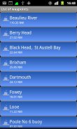
•View waypoints alphabetically of by distance from your current position.
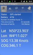
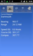
•Display range and bearing to a waypoint.
•Make logs of where you have been, which you can annotate with comments and other relevant data.
•View logs as display on the phone.
•Share logs with Google Earth on your phone or desktop computer, either by email or by copying KML files.
•Share waypoints with Google Earth on your phone or desktop computer, either by email or by copying KML files.
•Share logs with Google Earth on your phone or desktop computer, either by email or by copying KML files. Although I don’t encourage the use of Google Earth for marine navigation, seeing your waypoints on Google Earth is a useful visual check that you have transcribed them correctly.
•Anchor watch alarm service. Alerts you if you have moved more than a pre-defined distance. The anchor watch also alerts you if the battery level is low.
•Near waypoint alarm service
•Once started, the log, anchor and waypoint alarm services will continue to run, even if you quit the main navigator application. They will continue to run while you make phone calls or use your phone for email, Internet browsing or pretty much anything else.
What this application is not
It is not a chart plotter. This application is intended for marine navigation. Although it could be used by ramblers, that isn’t the main intention. It does not display digitised charts, nor does it show you a Google Map view with your position displayed on it. I believe it is highly irresponsible to encourage the use of Google maps to navigate boats. Even in rivers and estuaries, Google maps contain no semantics for the sea whatsoever; no lights and marks, depths, rocks etc. The application does allow you to send logs you have made to Google Maps, though, but only after you have completed the trip.
Free Version
For a limited time, a free version is available. In the Autumn of 2012 a full feature version should be available.
The free version has the following limitations:
•The number of waypoints you can have is restricted to 20.
•Routes are not available
</div> <div class="id-app-translated-desc" style="display:none">我开始写这个应用程序,这将是对我有用的东西。从那时起,它已经成长,我感到很高兴。这是一个海上航行的援助,必须使用结合,白色的东西,被称为(所以告诉我)的纸张上打印的图表。
特点
•设计的水手。您可能会发现一些布局看“大和blobby”的一见钟情,但他们在海上工作。不繁琐和繁琐的布局。
•网络。此应用程序使用手机上的GPS,它会在没有移动网络覆盖范围(虽然你将需要网络覆盖范围,通过电子邮件分享您的日志和航点)。
•存储无限航点限制的免费版本。
•按字母顺序查看航点的距离您当前的位置。
•显示到航路点的距离和方位。
•日志,你有,你可以注解的意见和其他有关资料。
•查看日志显示在手机上。
•分享日志与谷歌地球“在您的手机或台式电脑,通过电子邮件或复制的KML文件。
•分享与谷歌地球“的航点,在您的手机或台式电脑,通过电子邮件或复制的KML文件。
•分享日志与谷歌地球“在您的手机或台式电脑,通过电子邮件或复制的KML文件。虽然我不鼓励使用谷歌地球的海洋导航,谷歌地球上看到您的航点是的视觉检查您是否已正确转录他们一个有用的。
•锚值班报警服务。提醒您,如果您移动距离超过预先定义的。锚手表也提醒您,如果电池电量低。
•近航路点报警服务
•一旦开始,日志,锚,航点报警服务将继续运行,即使你退出主Navigator应用程序。他们将继续运行,而你拨打电话或使用手机发送电子邮件,上网浏览或几乎任何东西。
这个应用程序是不
这不是一个海图。此应用程序是用于海上导航。尽管可以使用的漫步者,是不是主要目的。它不显示数字化的图表,也不会显示谷歌地图视图显示您的位置就可以了。我相信这是极不负责任的,以鼓励使用谷歌地图导航船。即使是在河流和河口,谷歌地图中没有任何语义海,没有灯和标志,深度,岩石等应用程序允许您发送您所做的谷歌地图,虽然,但只有在你已经完成了的日志之旅。
免费版本
为了在有限的时间内,一个免费的版本是可用的。在2012年的秋天,一个全功能的版本应该是可以的。
免费的版本有以下限制:
•你可以有航点的数量被限制为20。
•路由是无法使用</div> <div class="show-more-end">
Mad Mutt Marine GPS Navigator - 版本1.07
(04-08-2014)
Mad Mutt Marine GPS Navigator - APK信息
APK版本: 1.07程序包: uk.ac.plymouth.madmutt.gpsnavigatorMad Mutt Marine GPS Navigator的最新版本
其他版本


同类应用


